
The sport of trail running has seen a major spike in popularity in recent years, and who could argue with that when you see what places like Valais have in store for running enthusiasts. The Swiss has some of the most diverse topography and terrain just waiting to be explored. Trail runners can expect to take on dramatic mountains, towering peaks, thick forest, and lush pastures in this Mecca for fans of the outdoors.
“Valais has something for every calibre of athlete”
Whether you’re just starting your trail runner journey or you’re borderline elite-level, you’ll find that Valais has something for every calibre of athlete. Do yourself a big favour in 2021, and immerse yourself in the Swiss Alps.
Along the Aletsch Glacier, Bettmeralp
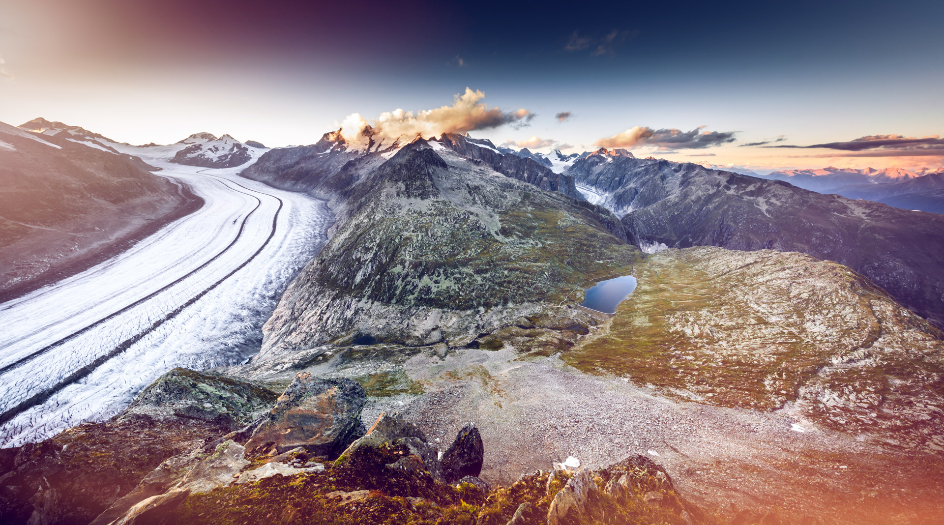
If you’re looking for a way to ease into your visit to Valais, then you can’t go wrong with this trail route that will take you along the Aletsch Glacier in Bettmeralp. The estimated time it takes is around the five-hour mark, but don’t be surprised if it takes much longer as you stop to admire the glorious glacier. This glacier, by the way, just so happens to be the largest in the Alps.
27km in length, this trail run will be taxing but very worth it as you set to work taking in all the natural beauty that Valais has to offer. This route is best accessible from July to October, where you can expect to ascend nearly 878 metres.
“This glacier… just so happens to be the largest in the Alps”
The area has been a UNESCO World Heritage Site since 2001 and is positioned in the heart of the region. The Aletsch Glacier is 1,000 metres thick, with the trail run alongside this piece of ice moving down a slope that will bring you to views of adjacent peaks – including the iconic Matterhorn and Weisshorn.
If you’re feeling weary by the halfway point, then you can always stop to recuperate at the Gletscherstube Märjelen hut. This place not only provides refreshments but is a great vantage point to take in the surroundings as well.
Val Ferret from La Fouly

Away from the Aletsch Glacier in the opposite direction is Val Ferret, a place home to a breathtaking view of the Italian-Swiss valley with all of its jagged mountains. This route is over 21km, and will provide you with a weighty 1,280 metres of ascent. You’ll be working those calf muscles, that’s for sure.
“This route is over 21km, and will provide you with a weighty 1,280 metres of ascent”
When you exit the village of La Fouly, take the pathway that rises to the Petit col Ferret. Soon after, you’ll make a sharp turn at the Gîte de la Léchère, where you come across grassy pastures and the rocky terrain of the Taves du Dolent.
As you start to catch your breath on this route, you’ll reach the first pass and see the spectacular view of the Val Ferret. After you’re done here, then get ready to make the short trip to Italy as you cross over the border into large grasslands before returning to Swiss soil via the Grand Col Ferret.
Via Valais Cabane d’Essertze – Cabane des Aiguilles Rouges (Stage 2)
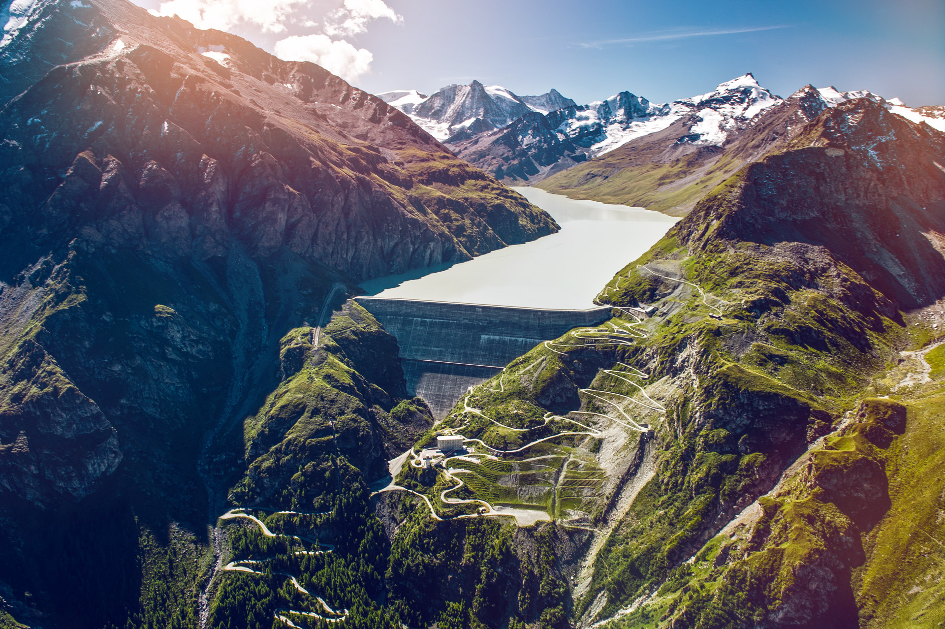
Now it’s time to up the ante as we take you on this 30 kilometre long adventure that will take you to a height of 1,783 metres. This trail running route will take you the best part of six hours and 25 minutes to complete.
A quick start will see you reach Grande Dixence, the highest gravity dam in the world. After this point, you can enjoy some flatness before reaching the very steep climb of Pas de Chèvres. July to September is the prime time to give this trail run a go but be warned, this route is very difficult. It’s advised you have some form of trail running experience before taking on Via Valais.
“A quick start will see you reach Grande Dixence, the highest gravity dam in the world”
You’ll need to make a crossing between Pas de Chèvres and Mont Blanc de Cheilon. To aid you is a series of stairs and ladders that will make this run feel like a proper Swiss adventure.
One final climb, and you’ll reach Aiguilles Rouges hut – situated at 2,810 metres. Indulge in a home-made tart while you’re there.


